
Civil Engineering
Urban Water System
🕛 October - December 2024
🚰 Role: Water Systems & Urban Planning
📍 CIV_ENG_368 (“Sustainability: The City”)
👥 Collaborating with 3 students across multiple engineering disciplines
Overview
The Evanston Eco-Commons project involved designing an entire site plan, transforming a former big-box shopping center into a sustainable, adaptable, and resilient urban space. I independently led the design of the water management system, which integrated stormwater and greywater reuse to reduce potable water demand, mitigate flooding, and enhance ecological resilience. Building it entirely from scratch—without templates or proprietary tools—I iteratively refined the design, adapting to evolving land use considerations and aligning technical solutions with the site’s unique needs.
📊 Quantitative System Design (Excel, Python)
🔢 Performance Benchmarking
🗺️ Land Use / Urban Planning (Collaborative)
1. Understanding the Problem
Core Challenges
I set out to understand the needs of the existing community with my team, beginning with a site visit. I identified these major challenges relevant to the water system:
Aging infrastructure ill-equipped to handle increasing storm intensities.
Overreliance on potable water for non-potable uses.
Lack of integration between greywater and stormwater systems.
Insufficient visibility into water usage and cycles for community engagement.
Limited space for new infrastructure within a dense urban environment.
Minimal ecological support in existing stormwater solutions.
To develop a thoughtful urban space with my team and water system on my own, I had to interpret site-specific land use changes and translate population and square footage data into actionable benchmarks for water management.
Setting Goals
Capture & Reuse
Capture 100% of the 10-year, 24-hour storm runoff (1.57M gallons), with storage for at least 30% of that volume
Reduce potable water demand by >70% using non-potable systems, supported by 100% greywater contribution (95,340 gpd).
Ensure overflow from storage is redirected seamlessly, maintaining resilience under extreme conditions.

Aerial view of the site, outlined on Google Earth.
A video from our site visit, which included a walk-through, drive-through, and discussions with community members.
Community Integration
Ensure that some features meet recreational needs and/or create visibility into water use cycles
2. Demand Management
The foundation of Evanston Eco-Commons' water management strategy was built on a detailed analysis of potable water use, greywater generation, and wastewater flows. While these calculations set the stage for understanding the site’s broader water needs, their primary purpose was to identify key benchmarks for subsequent stormwater and greywater system design.
Key Calculations
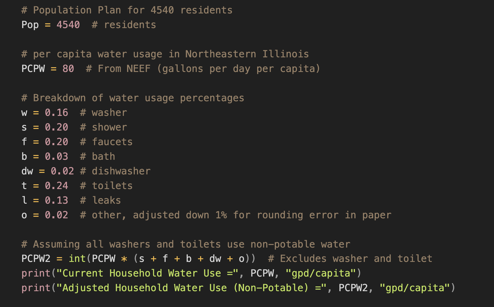
Residential Potable Water Demand: Using regional per capita averages of 80 gallons per day (NEEF) for 4,540 residents, the baseline demand was calculated at 363,200 gpd in a “do-nothing” scenario.
Greywater Generation: Showers, faucets, and other non-potable uses contributed an estimated 95,340 gpd, creating opportunities for greywater reuse.
Commercial Water Demand: Factoring a 30% reduction from standard water use (20 gal/sf/year) yielded a target of 11,229 gpd.
Initial setup for calculations. See this Notion page for the rest of the calculations.
Key Benchmarks for Design
These calculations directly informed the greywater system capacity and stormwater integration strategies:
The estimated 95,340 gpd of greywater served as a baseline for sizing treatment systems and storage infrastructure.
By comparing residential potable water demand in a “do-nothing” scenario to the proposed interventions (e.g., low-flow fixtures, rerouting non-potable uses), the project achieved a 73.75% reduction in potable water use.
This early modeling provided clarity on the volumes and flows that would need to be managed throughout the system. While potable water usage itself required no ongoing design adjustments, these benchmarks were critical for ensuring greywater and stormwater systems could function as an integrated, closed-loop solution.

3. Stormwater / Graywater Infrastructure
The Holy Grail of Iteration
To understand system needs, I started by evaluating the catchment areas, runoff coefficients, and precipitation data. As I continued building on my calculations to understand relationships between the data, I confronted spreadsheet creative block with sketches of flows, putting the numbers to paper.
A breakdown of types of calculations and their influence on several key points of iteration are shown below.

Final Decisions
Infrastructure Scaling
To meet storage demands while minimizing environmental and urban impact, I proposed a hybrid system of decentralized cisterns and a centralized water feature with an 8M-gallon capacity.
Stormwater & Greywater Integration
The system integrates greywater treatment through wetlands and stormwater capture, with modular Stormbrixx cisterns supporting flexible storage capacities.
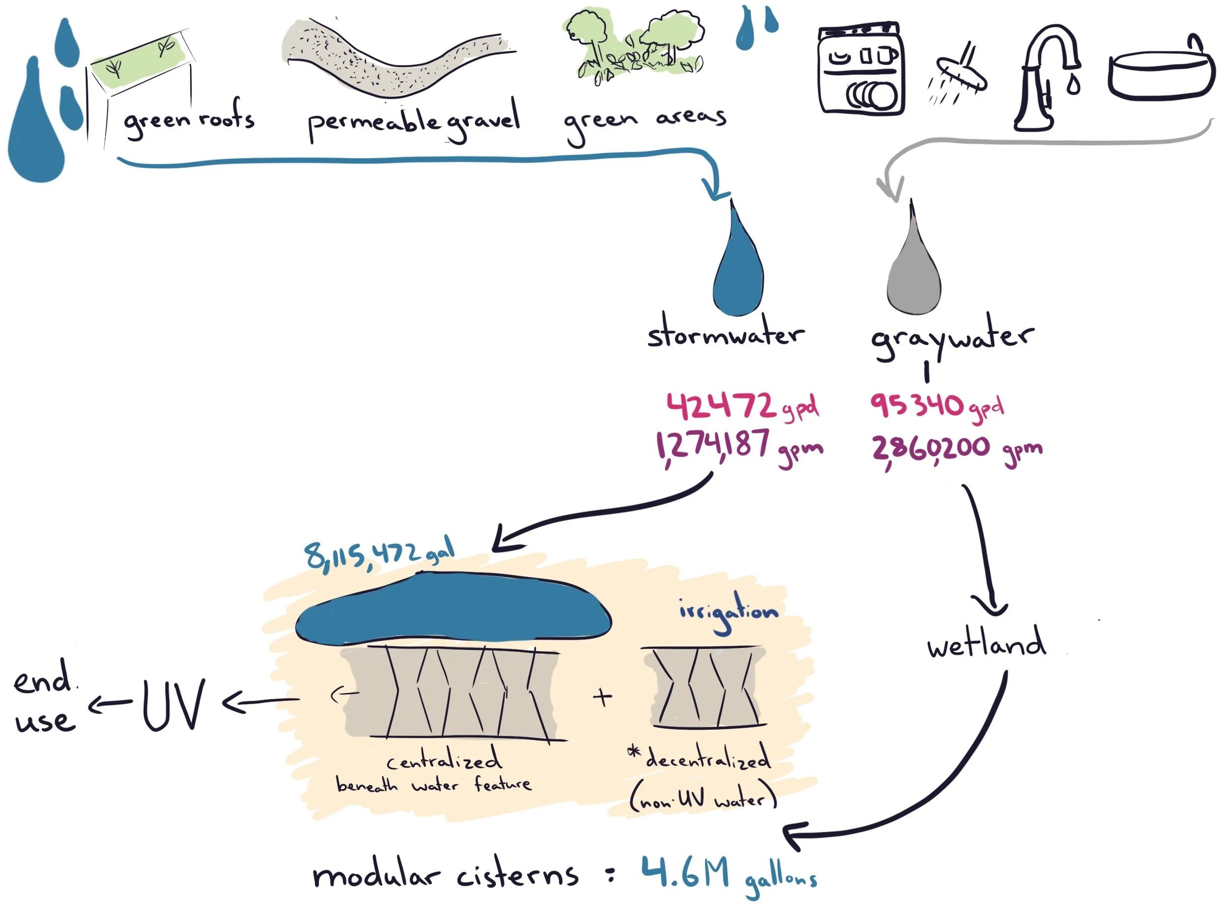
Flow diagram of the combined stormwater and graywater system. Capturable runoff for green roofs, permeable gravel, green areas, and other spaces was calculated using their respective runoff coefficients.
Water Feature
The water feature serves as both a recreational highlight and a visible component of the site's stormwater management system. Designed to adapt to varying conditions, it engages visitors by making its functions visible. Level markers and interpretive signage show real-time water levels and explain their significance, reinforcing the system's role in reducing potable water use and mitigating floods. This design bridges ecological functionality and community education, ensuring every drop supports both nature and people.
Municipal Systems for Wastewater and Potable Water
Due to our site’s proximity (1.5 mi) to the O’Brien Water Reclamation Plant and the footprint of the site, I decided to send our wastewater for treatment here, but opted for a new piping system to eliminate the 14% of treated water that currently leaks from aging pipes.
I also opted to continue sending water offsite for potable water treatment, as the implementation of this system on site is not financially or geographically feasible.

O’Brien Water Reclamation Plant, in close proximity to our site (Google Earth).
Outcome Overview
Beyond designing the Evanston HydroCycle, I collaborated on critical aspects of the broader Eco-Commons project, including shelter design and land use optimization to support sustainable density. This meant calculating square footages, ensuring adequate population capacity, and balancing shared green spaces with essential infrastructure. The water system mimics a natural hydrologic cycle—capturing stormwater, treating it in wetlands, storing it in cisterns, and distributing it for everyday use. By ensuring these systems serve people and the environment, the design delivers a community-oriented solution that blends utility with sustainability.

This aerial view of Evanston Eco-Commons was created by teammate Hannah Aziz.